


3. A Foothold in the New World
Located: 1st Floor, alcove outside Clerk’s Office and Courtroom A
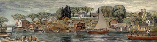
Print in courthouse exhibit: John W. Hatch (Professor, University of New Hampshire), The Falls, mural of Durham, N.H., c. 1822 (1954); Community Church of Durham.
This painting presents a view of the active life of New Hampshire farmers and mill owners who regularly shipped goods to and from the seacoast via gundalows, aided by the currents of of tidal rivers. New Hampshire’s economy centered around the resources of the Portsmouth area and the Piscataqua River basin, including the pictured Oyster River, from the earliest settlements in 1623 until the early 1700s, when the extraordinary quality of her inland forests was also recognized. At that point, the supplying of enormous ships’ masts for the British fleet took off in earnest. Shipbuilding continued as a prime industry of the area. By the 1760s, as the relatively prosperous state’s interior development and population rose dramatically, the rumblings of political unease in colonial America was intensifying. All the while, the Piscataqua and other rivers in the area continued to play an important role in trade.

A Foothold in the New World
In 1614, Captain John Smith surveyed the “high, craggy, cliffy rocks and stony isles” of the northern New England coast, finding them “rather to affright than delight.” However, the isles’ “good woods, springs, fruits, fish and fowl” led Smith to expect that “the valleys, plains, and interior parts may well (notwithstanding) be very fertile.” This promising Description of New England (1616) tempted the English monarchy as an opportunity for colonization and profit.
King James I soon authorized land grants for “New-England in America,” stretching from modern-day Delaware to Nova Scotia, and “from sea to sea.” Captain John Mason of Hampshire, England, entrusted with ownership rights extending inland some sixty miles from the mouths of the Merrimack and Piscataqua Rivers, organized expeditions to establish fishing and trading stations in the region he called New Hampshire.
The process of colonizing New Hampshire proved as rocky as its shoreline. David Thomson settled Pannaway Plantation at Little Harbor (Rye) in 1623, but abandoned it three years later. A group of Edward Hilton’s men landed at Pomeroy’s Cove (Dover) in 1623, but it was a full ten years before a colony of English families would follow. In 1629, Captain John Mason’s Laconia Company sponsored a settlement at Strawbery Banke (Portsmouth), only to encounter financial strains and recall its discouraged company representatives to London by 1634.
Shortly after Mason’s death in 1635, Puritans from the Massachusetts Bay colony extended their influence northward by founding two New Hampshire communities: Exeter (1638) and Hampton (1639). Merchants from Massachusetts Bay were also drawn to Strawbery Banke, and soon dominated its economy and society. In dire need of governmental structure, the four established towns (today’s Dover, Portsmouth, Exeter and Hampton) consented in 1641 to join the Massachusetts Bay colony. Meanwhile, Captain John Mason’s heirs claimed extensive property ownership under Mason’s original land grant. Their persistence vexed would-be settlers of the New Hampshire frontier and courts on both sides of the Atlantic for nearly a century. Settlement was also slowed by the colonists’ fear of the wrath of remaining native tribes. While the Province of New Hampshire was first designated in 1679, it was 1741 before King George II finally determined New Hampshire’s boundary with Massachusetts and appointed Benning Wentworth as the province’s colonial governor. Soon thereafter, Mason’s heirs sold their claims. By the 1760s, colonial New Hampshire’s western boundary was defined, and its population and interior development were on the upswing.
Exports and Imports
Fish— particularly cod— was New Hampshire’s first major export. In the mid-1660s, as many as 1,500 men worked on the Isle of Shoals drying and salting cod catches: 100,000-120,000 pounds of cod were shipped annually to Europe and the West Indies. By the early 1700s, however, New Hampshire’s fishing industry was surpassed by coastal Massachusetts’ operations. It became clear that New Hampshire’s real wealth lay in the forests, not the sea.
Europe had experienced serious deforestation since the twelfth century; and New Hampshire’s tall, exceptionally strong white pines perfectly suited England’s demand for ship masts. The royal office of Surveyor General of His Majesty’s Woods and Forests in America was established in 1729, and the choicest pines in New Hampshire’s forestland were marked as reserved for the Royal Navy. Thousands of masts, as well as barrel staves, casks, clapboards, shingles, and pipe staves, were shipped to England between 1690 and 1775.
The mast trade directly spawned another major industry for colonial New Hampshire: shipbuilding. Shipwrights along the Piscataqua River built new “mast ships” capable of transporting the giant stripped pines across the Atlantic. New Hampshire shipbuilders also profited from the development of trade routes between Africa, the Caribbean, North America, and Europe. The demand for merchant ships twice the size of early seventeenth-century ships gave New Hampshire an inroad into the highly lucrative trade network.
Much of seventeenth- and eighteenth-century New Hampshire mirrored prevailing social and political themes across the colonies. Thus, New Hampshire’s direct involvement in the slave trade played a role in assuring the region’s early economic viability. Ships from New Hampshire carried cod and timber products to the American south and the West Indies, and returned with cargo to be marketed, including cotton, rice, cocoa, rum, molasses, sugar, and slaves. Half a dozen New Hampshire merchants regularly sailed between Africa, Barbados, and Virginia in the mid-1700s. This expansion of commercial shipping provided a solid economic base for the seacoast towns, while agriculture and forestry work supported the increasing settlement of inland New Hampshire.
River Traffic
New Hampshire’s economic development in the eighteenth and nineteenth centuries heavily depended on river freight. Without easily passable roads, farmers and tradesmen relied on “gundalows”: flat bottomed, barge-like boats that masterfully traversed the Piscataqua River and Great Bay estuary. Gundalows made travel fast and efficient. The key was the river’s tidal current—an unaided gundalow could travel from the Great Bay to Portsmouth and back on one twelve-hour tide. Simple design and easy maintenance made gundalows the ultimate cargo vessel; they were the eighteen wheelers of their day. Farmers’ gundalows, loaded with harvested crops, bricks, salt marsh hay and timber, were sent down river to Portsmouth in exchange for manufactured goods like cloth, furniture, and china, as well as coffee and tea.
As the Piscataqua region settled into a working rhythm, New Hampshire colonists moved further into the frontier. Industrious “yeoman” farmers cleared forestland for agricultural use. Over the following century, they dammed waterways to power saw and grist mills, built meetinghouses and schools, and established their own local leadership. By 1775, New Hampshire was home to 147 chartered towns.
A Revolutionary Turn
The deep waters of Portsmouth Harbor had hosted America’s first construction of a naval warship in 1690 (the British Royal Navy’s HMS Falkland) and several other British vessels. By 1775, however, the colonists’ evolving national ideals re-directed Portsmouth’s shipbuilding industry. Now it was time for a Continental fleet. Portsmouth readily took on work in support of the War for Independence, producing the Raleigh, the Ranger and the America in quick succession. The founding in 1800 of the Portsmouth Naval Shipyard, the young nation’s first federal drydocks, ensured the area’s United States Navy connection that continues to the present day.
The Falls - (John W. Hatch)